


route: Ślesin - Głębockie Pierwsze - Witalisów - Obory - Mielno - Noć - Kalina - Broniszewo - Przewóz - Mielnica Duża - Mielnica Mała - Goplana - Warzymowo - Kolonia Warzymowska - Koszewo - Gawrony - Żółwieniec - Ostrowy - Ślesin
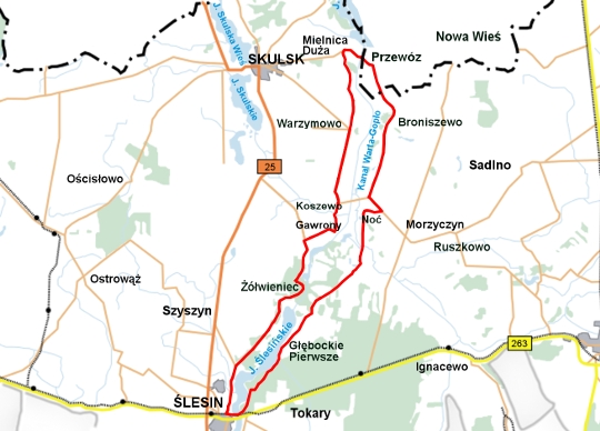
Length: 32,5 km
Estimated time: 2,10 h
Marking: kolor zielony
TRAIL ADMINISTRATOR:
Ślesin Commune
ul. Kleczewska 15
62-561 Ślesin
phone +48 63 270 40 11 wew. 231
www.slesin.pl
promocja@slesin.pl
Trail Description:
0.0 km
The trail starts at the viewing promenade in the city park in Ślesin. We head toward the bridge, after which we descend the trail, riding along the lake and entering the forest.
2.2 km
We reach an asphalt road and continue on it. After about 1 km, we reach a bridge over the discharge canal. We ride through the village of Głębockie Pierwsze on the asphalt road.
5.0 km
We enter the village of Witalisów. There is a turn: the asphalt road turns right, and we take a dirt road. We pass straight through a trail fork. We continue riding through fields and forests.
7.2 km
We are in the village of Obory. We enter an asphalt road. After about 1 km, we reach a bridge over the Noteć River. On the left, we pass a historic water mill. We continue on a dirt road.
9.7 km
We reach an asphalt road. We turn left, and after 500 meters, we are in the village of Kalina. We continue on the asphalt road, turning right through the village.
13.5 km
In Broniszewo, we pass a historic church. We continue on the asphalt road. In the village of Przewóz, we turn left at the intersection. We pass a bridge over the Warta-Gopło Canal.
17.0 km
Mielnica Duża. We are now in the area of the Nadgoplański Millennium Park. We turn left, taking a dirt road. On the right, we pass a gravel pit. We enter an asphalt road and reach Goplana.
19.5 km
Warzymowo. You can turn left to visit the historic church. At the road fork, we continue straight.
22.5 km
We pass through Koszewo. We leave the asphalt road for a dirt road. After about 2 km, we reach the edge of the village of Gawrony, where we turn left and continue on the dirt road. We enter the forest and pass a small glacial lake on the left, charmingly named Kociołek.
26.5 km
Żółwieniec. We reach a bridge over the Warta-Gopło Canal. Near the bridge, we can see bunkers from World War II. After the bridge, we turn left and continue on the dirt road.
28.0 km
We arrive in Stanisławów. We reach an asphalt road and continue on it, passing forests and buildings, with a radio and TV mast on the right.
30.3 km
We reach the road Skulsk - Ślesin. We turn left toward Ślesin. Passing through Ślesin, we pass a church and an obelisk dedicated to the memory of Pope John Paul II on the left. After the obelisk, we turn left.
32.5 km
The trail ends at the promenade in the park.