


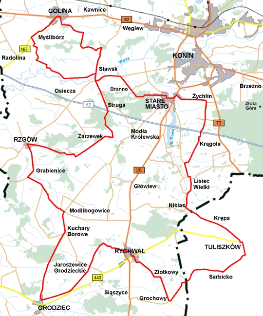
 route: Stare Miasto - Tuliszków - Rychwał - Grodziec - Rzgów - Golina - Stare Miasto
| Length: 96,9 km Estimated time: 6,30 h Marking: red TRAIL ADMINISTRATOR:
Association 'SOLIDARITY in PARTNERSHIP' ul. Główna 16, 62-571 STARE MIASTO tel. +48 63 241 62 16 w. 45 www.sswp.com.pl lgd@stare-miasto.pl |
 |
TRAIL DESCRIPTION:
0.0 km
Old Town. The trail begins at the Municipal Office building. We head east and pass under the busy national road No. 25. At the intersection, we turn left. We follow National Road No. 25. After about 500 meters, we turn right towards Żychlin.
3.2 km
In Żychlin, we turn right. At the next intersection, we continue straight towards Janowice. On our left, we can see the Bronikowski Palace (currently the ZSEU building in Żychlin).
4.6 km
Janowice. We continue straight along the asphalt road. After 800 meters, we enter a viaduct over the A2 motorway. We then enter Krągola. The road leads us further. First, we turn right, then shortly after, at the intersection, we turn left.
6.9 km
Road split. We continue straight. The asphalt turns into a gravel surface.
8.4 km
Lisiec Mały. We turn right and return to the asphalt road. At the next intersection, we turn left. We continue straight, passing through Lisiec Wielki, and then Niklas.
13.0 km
Road split. We turn left towards the village of Krępa.
16.8 km
We enter Tuliszków. We continue straight along Targowa Street. After about 1 km, we turn left onto Mickiewicza Street.
17.7 km
Square by the Fire Department (OSP). We turn right onto Floriańska Street. After about 100 meters, we turn left onto Poznańska Street. On the left, we pass the Church of St. Vitus. We turn right onto T. Rogoziński Street. At the intersection, we follow the sign to Sarbicko.
23.6 km
We cross the county road. The asphalt road turns into a gravel road. After the settlement of Paluszek, we turn left.
26.7 km
Grochowy. We enter the asphalt road. We turn right and continue straight. We pass Złotkowy. We keep going straight to Rychwał, entering Złotkowska Street.
31.5 km
Rychwał. We cross Tuliszkowska Street (Voivodeship Road No. 434) and, after several turns, reach Freedom Square. By continuing straight on Kościelna Street, we would reach the Church of the Holy Trinity. However, we turn right onto Konińska Street and immediately left onto Grabowska Street. We cross National Road No. 25. Be careful of heavy traffic.
34.9 km
The asphalt road ends. We turn left and continue along a road by the edge of the forest. After 300 meters, at the road junction, we turn left.
36.1 km
Jaroszewice Grodzieckie. We continue straight through the intersection. We enter an asphalt road, which then turns into a gravel road, and after another 500 meters, becomes sandy.
39.5 km
We return to the asphalt road. We turn right towards Grodziec. We reach an intersection in Grodziec. About 1.5 km to the south is the Forest Education Center. However, we turn right and head north, passing through Wielołęka, Aleksandrówek, and Kuchary Borowe.
49.6 km
Modlibogowice. At the intersection, we turn left. We head towards Pyzdry. After about 1 km, at the intersection, we turn right.
54.6 km
Grabienice. We pass by the Church of St. Catherine. We continue along the main road, which leads us left.
56.5 km
We enter Rzgów. At the intersection, we turn right. After about 1.5 km, we enter the forest. Occasionally, we drive on very sandy stretches.
61.7 km
Zarzewek. For a moment, we are back on asphalt. We continue straight. The road turns back to gravel. At the intersection with the asphalt road, we turn left. The road goes among the trees. We pass over the motorway.
67.3 km
Struga. On the left, we pass a monument with the inscription: "In memory of the murdered inhabitants of Kowalewka by the Nazis on January 15, 1945."
69.3 km
Sławsk. We cross the county road and, after 60 meters, turn right towards the ferry. We cross to the other side of the Warta River (the ferry operates free of charge: Monday to Friday, the first Saturday of the month from 5:00 AM to 9:00 PM, other Saturdays, Sundays, and holidays from 7:00 AM to 3:00 PM). After crossing the river, we turn left and continue along the concrete slab road by the flood embankment, with meadows along the Warta River on the right.
74.6 km
Attention! We turn right at a barely visible turnoff, continuing along the concrete road through the meadows.
75.9 km
At the road junction, we turn right. We continue along the concrete road. After 500 meters, we turn left between buildings and shortly afterward (twice) turn left again.
77.9 km
Myślibórz. We pass the Church of St. Matthew the Apostle. Shortly after, we reach road No. 467 and turn right (beware of heavy traffic).
80.5 km
Golina. On the right, we pass the manor complex. At the roundabout, we turn right towards Konin. At the traffic lights, we turn right again. In front of the wooden Church of St. James the Apostle, we turn right. After 500 meters, we turn left and continue straight through the forest, followed by a grassy road through the meadows.
87.3 km
Upon reaching the asphalt road, we turn right, heading towards the ferry crossing in Sławsk. The asphalt road soon turns into sand. We cross the river.
89.8 km
We reach the county road and turn left. After 2 km, we turn right towards Branna.
93.3 km
Road junction. We continue straight along the sandy road through the forest. After 400 meters, we turn left. We emerge from the forest, and a settlement of single-family houses appears.
96.1 km
We pass by the primary school. We continue straight. Before the Fire Department building, the road turns right. We pass the Church of St. Peter and St. Paul. At the intersection, we turn left.
96.6 km
End of the trail at the Municipal Office in Old Town.