


 route: Warzymowo – Kolonia Warzymowska – Lisewo – Czartowo – Popielewo II – Paniewo – Skulska Wieś – Skulsk
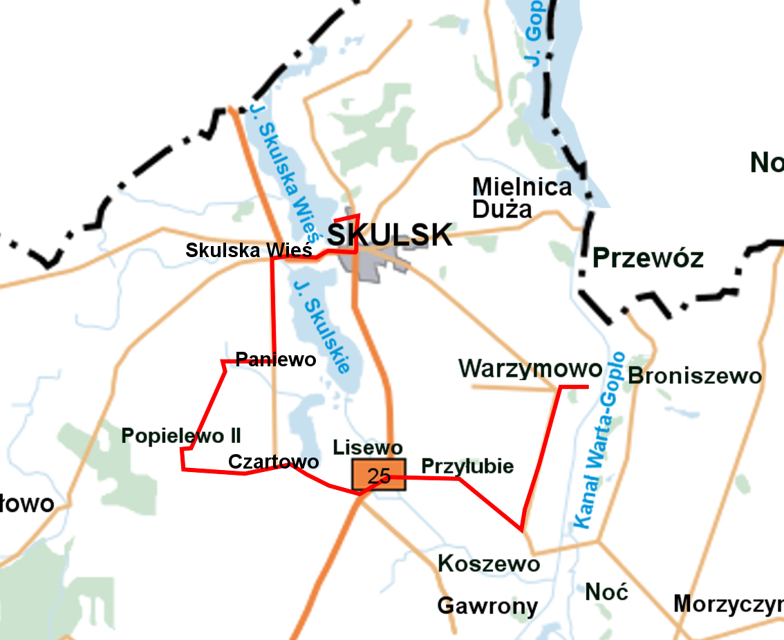
Length: 15,7 km
Estimated time: 1,10 h
Marking: blue
TRAIL ADMINISTRATOR:
Municipal Office in Skulsk
ul. Targowa 2
62-560 Skulsk
tel. +48 63 268 20 18
www.gmina-skulsk.pl
ug.skulsk@wp.pl
TRAIL DESCRIPTION:
0.0 km
The trail begins at the historic church in Warzymów, where we head west along the asphalt road that goes uphill. After 500 meters, we turn left. We continue for about 2.5 km towards Koszewo. We pass through Kolonia Warzymowska and reach an intersection.
2.90 km
At the intersection, we turn right. After about 2.9 km, we arrive in the village of Lisewo, where there is a historic palace. Upon reaching National Road No. 25, we turn left, and after 350 meters (at the second intersection), we turn right onto an asphalt road leading to the village of Czartowo. After about 1.2 km, we enter Czartowo. At the intersection, we go straight, leaving the asphalt road and turning onto a gravel road. After about 1.5 km, we turn right onto an asphalt road leading to Popielewo II. After about 350 meters, we reach Popielewo II, where you can see the renovated wooden chapel of St. Anthony and the restored park.
9.17 km
After about 1.5 km, we turn right and arrive in Paniewo. At the intersection, we turn left. We continue on the asphalt road for the next 1.6 km, reaching an intersection in the village of Skulska Wieś. We turn right, and after 280 meters, we reach the historic cemetery in Skulsk.
13.35 km
We enter Skulsk on National Road No. 25. On the right, we pass the sanctuary with the 15th-century Pietà of Our Lady of Sorrows. On the left is the Skulska Wieś lake. At the main intersection, we turn left, and after about 1 km, we reach the edge of the forest. We turn left towards the beach, which we reach after traveling 250 meters down a fairly steep road. This marks the end of the blue trail. At the beach, you can rent water equipment for free, use the water playground, and the outdoor gym. You can also walk along the educational and nature trail leading to the center of Skulsk.