


 route: Świątniki – Rzgów – Modła Rzgowska – Babia – Osiecza – Sławsk – Konin – Zalesie – Brzeźno – Rożek Brzeziński – Borowo – Roztoka – Drążno Holendry – Biechowy
| Length: 40,8 km Estimated time: 4,0 h Marking: blue |
 |
|
TRAIL ADMINISTRATOR:
Marshal's Office of the Greater Poland Voivodeship in Poznań ul. Piekary 17, 61-823 POZNAŃ phone +48 61 855 35 22 www.umww.pl ds.sekretariat@umww.pl |
 |
The Nadwarciański Bicycle Trail (257 km) stretches from Poznań to the Jeziorsko Reservoir and is one of the many currently functioning regional cycling trails in the Greater Poland Voivodeship. The trail begins in the capital of Greater Poland, Poznań, and ends at the eastern borders of the voivodeship. It connects a variety of sightseeing, architectural, and, above all, natural attractions located between Poznań and Jeziorsko. For the majority of its length, the trail runs close to the Warta River, offering cyclists views of fields, meadows, willow floodplains, and numerous oxbow lakes.
TRAIL DESCRIPTION:
138.8 km
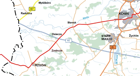
Czarna Struga – the western border of the Konin district. The trail runs along the southern boundary of the Nadwarciański Landscape Park.
140.3 km
We pass through Świątniki, and at the intersection, we turn left. A few hundred meters later, we enter Rzgów. On the left, we pass the wooden Church of St. James. We continue straight along the county road, passing through several villages: Modła Rzgowska, Zastruże, and Babia. We cross over the A2 motorway.
149.1 km
We reach Sławsk. We pass the church, with a road leading to the ferry crossing and the palace. We continue straight, and after about 5 km, the panorama of Konin unfolds before us.
156.4 km
We enter Konin. We pass straight through the intersection and then continue along Dąbrowskiego Street.
158.4 km
We reach Św. Ducha Roundabout. On the right is the Evangelical-Augsburg Church and the Franciscan monastery. At the roundabout, we turn left onto 3 Maja Street. After 600 meters, we turn right onto Szarych Szeregów Street.
At the roundabout, we continue straight (on the right, we pass a symbolic cross and plaque commemorating the execution of Fr. Maksymilian Tarejwo, a Capuchin friar, chaplain of the insurgent army, and emissary of the National Government). A few hundred meters later, we reach the pedestrian crossing on the so-called Warsaw Route. After crossing, we turn downhill onto Osada Street. We continue along the Warta River, passing Zalesie.
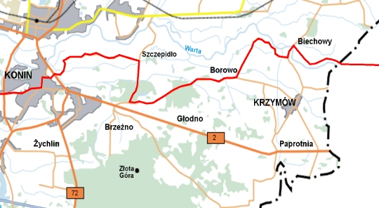
164.6 km
We reach Szczepidło. After the bus stop, we turn right. When we reach the perpendicular road, we turn left. We pass through the following villages: Brzezińskie Holendry, and Rożek Brzeziński.
172.0 km
We reach Borowo. We turn left onto the asphalt road heading north.
174.1 km
We enter the village of Drążno-Holendry. The winding road between the buildings leads us to the sign directing us to the ferry crossing. We turn left and reach the Warta River.
176.6 km
We cross the Warta River. The ferry in Biechowy operates on weekdays from 7:00 AM to 3:00 PM, and on Sundays and holidays from 8:00 AM to 2:00 PM.
176.9 km
On the second bank of the Warta River, we turn right, and the trail continues along an unpaved road beside the flood embankment.
179.3 km
We reach the eastern border of the Konin district. The trail continues eastward towards Koło.