


 trasa: Ślesin - Głębockie Pierwsze - Witalisów - Żółwieniec - Ostrowy - Ślesin
| Długość: 12,5 km Średni czas przejazdu: 0,50 h Oznakowanie: kolor zielony ZARZĄDCA SZLAKU:
Towarzystwo Społeczno-Gospodarcze "DWA MOSTY" 62-561 ŚLESIN-TOKARY tel. +48 63 270 41 27 www.dwamosty.pl prezes@dwamosty.pl |
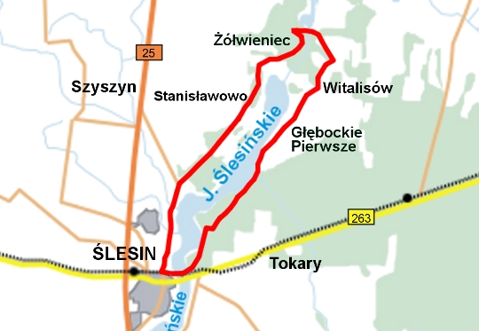 |
ROUTE DESCRIPTION:
0.0 km
Ślesin. The trail begins at the viewing promenade in the city park. We head towards the bridge, and after crossing it, we descend along the trail, riding along the lake and entering the forest.
2.2 km
We reach an asphalt road. We continue on the asphalt road. After about 1 km, we reach a bridge over the discharge canal. We continue along the asphalt road through the village of Głębockie Pierwsze.
5.0 km
We enter the village of Witalisów. A turn: the asphalt road turns to the right, and we descend onto a dirt road. At the trail junction, we turn left. We continue on the dirt road.
6.6 km
Żółwieniec. We reach the bridge over the Warta-Gopło Canal. Near the bridge, we can view bunkers from World War II. After the bridge, we turn left and continue along the dirt road. On the left, we pass a radio and television mast.
8.0 km
We reach Stanisławów. We reach an asphalt road. We continue on this road, with Lake Ślesińskie on our left.
10.3 km
We reach the Skulsk - Ślesin road. We turn left towards Ślesin. As we pass through Ślesin, we pass the church on the left and a memorial dedicated to Pope John Paul II. After the memorial, we turn left.
12.5 km
The trail ends at the promenade in the park.